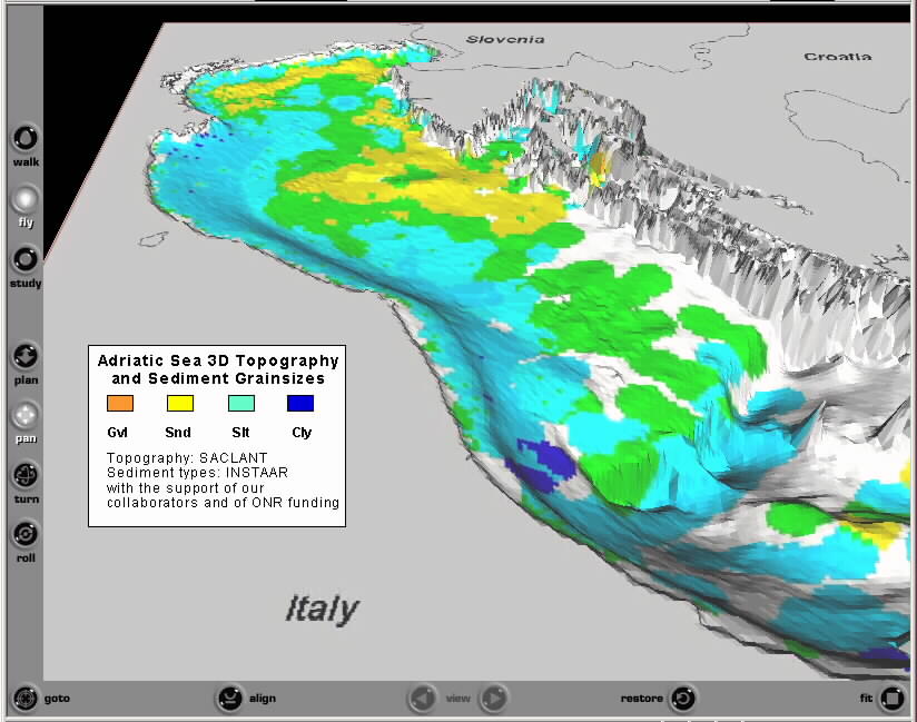
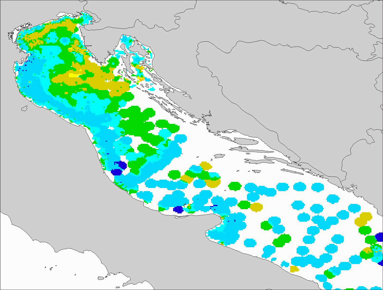
Published
Data
Sources
We thank the authors of these papers for their contributions
to
the mapping.
- F. Ken McKinney, 2003. Preservation Potential and
Paleoecological
Significance
of Epibenthic Suspension Feeder-Dominated Benthic Communities (Northern
Adriatic Sea), Palaios, 18, 47–62.
- Peter C. Dworschak, 2002. The burrows of Callianassa
candida (Olivi
1792)
and C. whitei Sakai 1999 (Crustacea: Decapoda: Thalassinidea) In:
Bright,
M., P.C. Dworschak & M. Stachowitsch (Eds.) 2002: The Vienna
School
of Marine Biology: A Tribute to Jörg Ott. Facultas
Universitätsverlag,
Wien: ##, p.63-71.
- Mladen Juracic, 1999. Seabed and Surface Sediment Map of
the Kvarner
Region,
Adriatic Sea, Croatia (Lithological Map, 1:500,000), Geol. Croat., 52/2,
131 – 140.
- A. D. Albani , V. M. Favero and R. Serandrei Barbero, 1998.
Distribution
of Sediment and Benthic Foraminifera in the Gulf of Venice, Italy. Estuarine,
Coastal and Shelf Science 46, 251–265.
- Mark G. J. Hartl 0 + Jorg A. Ott, ####. An In-Situ Study on
the
Influence
of Ascidian Suspension Feeding on the Subtidal Nepheloid Layer in the
Northern
Adriatic Sea. Marine Ecology, 19, 248-261.
- N. Calanchi, A. Cattaneo, E. Dinelli, G. Gasparotto, F.
Lucchini, 1998.
Tephra layers in Late Quaternary sediments of the central Adriatic Sea,
Marine
Geology, 149, 191–209.
- G. Cespuglio, C. Piccinetti, A. Longinelli 1999. Oxygen and
carbon
isotope
profiles from Nassa mutabilisshells (Gastropoda): accretion rates and
biological
behaviour. Marine Biology, 135: 627-634.
- Stanislav Franciskovic-Bilinski, Halka Bilinski, Neda
Vdovic, Yoganand
Balagurunathan, Edward R. Dougherty, 2003. Application of image-based
granulometry
to siliceous and calcareous estuarine and marine sediments. Estuarine,
Coastal and Shelf Science 58, 227 –239.
- Herbert Kollmann & Michael Stachowitsch, 2001.
Long-Term Changes in
the Benthos of the Northern Adriatic Sea: A Phototransect Approach. Marine
Ecology, 22(1-2), 135.
- Brambati, A., Ciabatti, M., Fanzutti, G. P., Marabini, F.
&
Marocco,
R. 1983. A new sedimentological textural map of the Northern and
Central
Adriatic Sea. Bollettino di Oceanologia Teorica ed Applicata 1,
267–271.
- MARKO NOTAR , HERMINA LESKOV_SEK and JADRAN FAGANELI,
2001.
Composition,
Distribution and Sources of Polycyclic Aromatic Hydrocarbons in
Sediments
of the Gulf of Trieste, Northern Adriatic Sea. Marine Pollution
Bulletin,
42(1), 36-44.
- Leon Moodley, Carlo H.R. Heip, Jack J. Middelburg, 1998.
Benthic
activity
in sediments of the northwestern Adriatic Sea: sediment oxygen
consumption;
macro- and meiofauna dynamics. Journal of Sea Research 40,
263–280.
- Frank K. McKinney, Andrej Jaklin, 2001. Sediment
accumulation in a
shallow-water
meadow carpeted by a small erect bryozoan. Sedimentary Geology,
145, 397– 410.
- Anna Contia, Antonio Stefanonb, Gian Maria Zuppia, 2002.
Gas seeps and
rock formation in the northern Adriatic Sea. Continental Shelf
Research
22, 2333–2344.
- S. Covelli, J. Faganeli, M. Horvat and A. Brambati, 1999.
Porewater
Distribution
and Benthic Flux Measurements of Mercury and Methylmercury in the Gulf
of Trieste (Northern Adriatic Sea). Estuarine, Coastal and Shelf
Science,
48, 415–428.
- Antonio Cattaneo, Annamaria Correggiari, Leonardo Langone,
Fabio
Trincardi,
2003. The late-Holocene Gargano subaqueous delta, Adriatic shelf:
Sediment
pathways and supply fluctuations. Marine Geology 193, 61-91.
- F. ALVISI, S. ALBERTAZZI, M. FRIGNANI, G. MAROZZI, M.
RAVAIOLI, 2001.
SAMPLING
AND DATING STRATEGIES IN STUDYING ENVIRONMENTS WITH HIGH SPATIAL AND
TEMPORAL
VARIABILITY. Archo Oceanogr. Limnol. 22, 207-216.
- Brambatti A & Marocco R 1983. Dispersion and
Sedimentation of
Industrial
Waste of Bauxite Blendes Fluorites and Phosphorites Dumped in the Gulf
of Venice Italy. Bolletino di Oceanologia Teorica ed Applicata,
3, 215.
- F. Oldfield, A. Asioli, C.A. Accorsi, A.M. Mercuri, S.
Juggins, L.
Langon,
T. Rolph, F. Trincardi, G. Wolff, Z. Gibbs, L. Vigliotti, M. Frignani,
K. van der Post, N., N. Branch, 2003. A high resolution late Holocene
palaeo
environmental record from the central Adriatic Sea. Quaternary
Science
Reviews 22, 319–342.
|
Published
Data
Sources (continued)
- Nives Ogrinc, Jadran Faganeli, Joze Pezdic, 2003.
Determination of
organic
carbon remineralization in near-shore marine sediments (Gulf of
Trieste,
Northern Adriatic) using stable carbon isotopes. Organic
Geochemistry
34, 681–692.
- N. Ogrinc, J. Faganeli, 2003. STABLE CARBON ISOTOPES IN
PORE WATERS OF
COASTAL MARINE SEDIMENTS (THE GULF OF TRIESTE, N ADRIATIC). Acta
Chim.
Slov. 2003, 50, 645-662.
- Nives Ogrinc and Jadran Faganeli, 2003. STABLE CARBON
ISOTOPES IN PORE
WATERS OF COASTAL MARINE SEDIMENTS (THE GULF OF TRIESTE, N ADRIATIC. Acta
Chim. Slov. 50, 645-662.
- Pigorini, P. 1967. Aspetti sedimentologici del Mare
Adriatico. Memorie
della Società Italiana di scienze Naturali-Milano.
- Pigorini P. 1968. Sources and dispersion of sediments of
the Adriatic
Sea. Marine
Geology 6, 187-229.
- Pranovi, F., Raicevich, S., Franceschini, G., Farrace, M.
G., and
Giovanardi,
O. 2000. Rapido trawling in the northern Adriatic Sea: effects on
benthic
communities in an experimental area. ICES Journal of Marine Science,
57: 517–524.
- Mariangela Ravaioli, Sonia Albertazzi, Francesca Alvisi,
Michele
Brunetti,
Mauro Frignani, Maurizio Maugeri, Teresa Nanni , ####. Records of
Climate
vs. Human Related Changes in Sediments of the Northern Adriatic Sea,
influenced
by the Discharge of Adige and Brenta Rivers, ###.
- D. Ridente, F. Trincardi , 2002. Eustatic and tectonic
control on
deposition
and lateral variability of Quaternary regressive sequences in the
Adriatic
basin (Italy). Marine Geology 184, 273-293.
- Timothy C. Rolph, Luigi Vigliotti, Frank Oldfield, 2004.
Mineral
magnetism
and geomagnetic secular variation of marine and lacustrine sediments
from
central Italy: timing and nature of local and regional Holocene
environmental
change. Quaternary Science Reviews 23, 1699–1722.
- Francesca Sangiorgi, Timme H. Donders, 2004.
Reconstructing 150
years
of eutrophication in the north-western Adriatic Sea (Italy) using
dinoflagellate
cysts, pollen and spores. Estuarine, Coastal and Shelf Science
60,
69-79.
- Fabio TRINCARDI, Antonio CATTANEO, Alessandra ASIOLI,
Annamaria
CORREGGIARI
and Leonardo LANGONE, 1996. Stratigraphy of the late-Quaternary
deposits
in the central Adriatic basin and the record of short-term climatic
events.
In: P. Guilizzoni and F. Oldfield (Guest Editors), Palaeoenvironmental
Analysis of Italian Crater Lake and Adriatic Sediments. Mem. Ist.
ital.
Idrobiol.; 55: 39-70.
- I. UJEVICÂ, N. ODZÏAK and A. BARICÂ, M,
2000. Trace
Metal
Accumulation in Different Grain Size fractions of the sediments from a
semi-enclosed bay heavily contaminated by urban and industrial
wastewaters. Wat.
Res., 34(11), 3055-3061.
- Vatova, A. 1935. Ricerche preliminari sulle biocenosi del
Golfo di
Rovigno. Thalassia
2:1-30.
- Vatova, A. 1949. La fauna bentonica dell’alto e medio
Adriatico. Nova Thalassia
1(3):1-110.
- C. Welker, E. Sdrigotti, S. Covelli, and J. Faganeli, 2002.
Microphytobenthos
in the Gulf of Trieste (Northern Adriatic Sea): Relationship with
Labile
Sedimentary Organic Matter and Nutrients. Estuarine, Coastal and
Shelf
Science, 55, 259–273.
- Cristina Zago, Gabriele Capodaglio, Sergio Ceradini,
Giovanni Ciceri,
Luisa
Abelmoschi, Francesco Soggia, Paolo Cescon, Giuseppe Scarponi,
2000.
Benthic fluxes of cadmium, lead, copper and nitrogen species in the
northern
Adriatic Sea in front of the River Po outflow, Italy. The Science
of
the Total Environment, 246, 121-137.
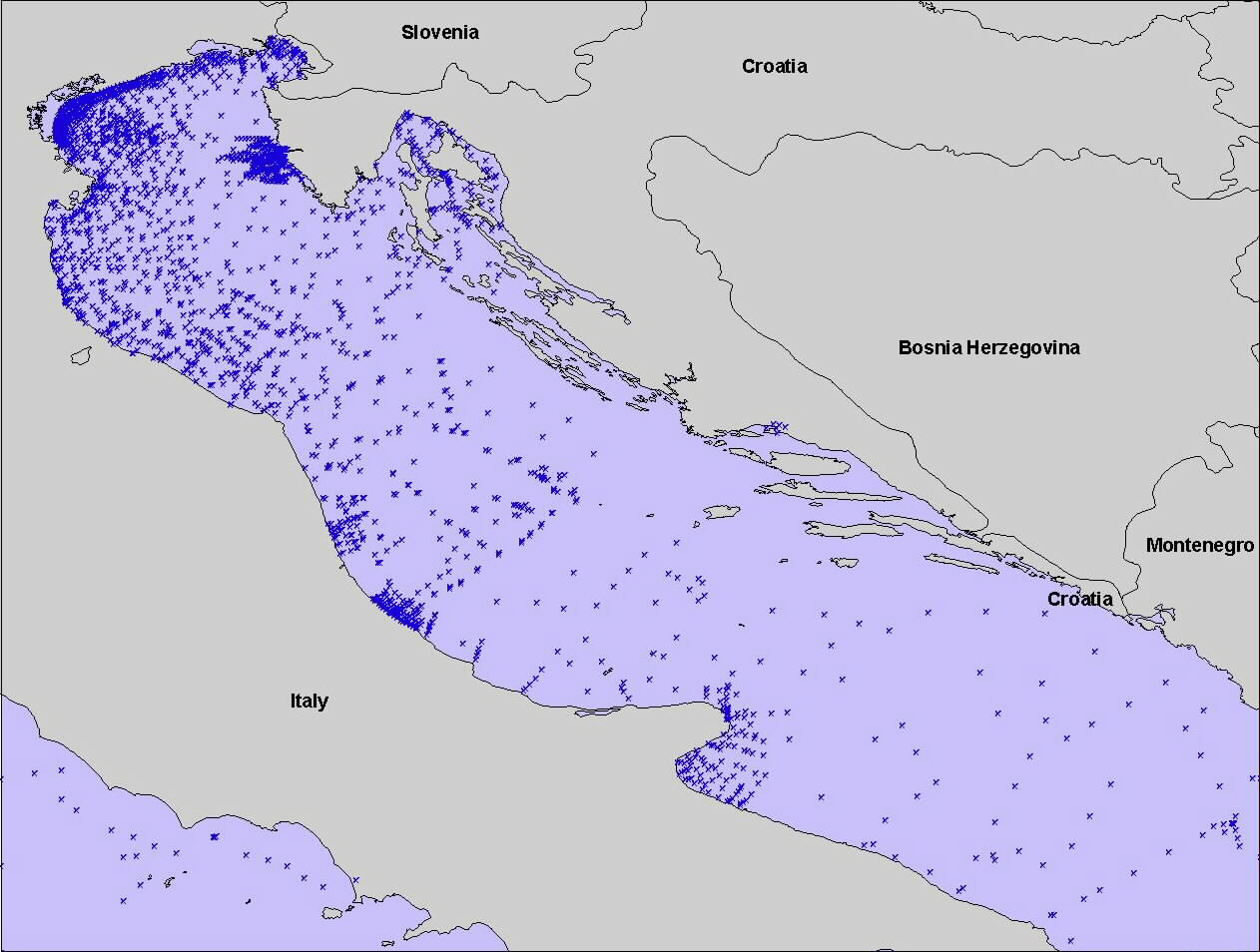
Unpublished Data Sources
We also thank these contributors of important unpublished
datasets.
- Richard Signell USGS [SACLANT datasets]
- F. Ken McKinney, Appalachian State Univ [personal data
collection]
- Alan Niedoroda, URS Corp [Palinkas and George datasets]
- Chris Sherwood, USGS [Chienti dataset, EuroSTRATAFORM]
- Albert Kettner INSTAAR (Po region beaches]
|