Institute
for Arctic
and Alpine Research,
University of
Colorado at
Boulder

USEFUL LINKS
dbSEABED
- Home
- Bibliography
- Methods
- FAQ
- CoreNavigator
usSEABED
- Home
- Atlantic Margin
- Gulf of Mexico
- Pacific Margin
Corewall
- The project
- CW
Wiki
- Corelyzer
Partners
- GSMFC
- INSTAAR
- PIES
- USGS CMG
- IOW
- USIMS
- NOAA NGDC
- UT Austin
|
Maximum A Posteriori Resampling of
Noisy Seabed Data
|
By John Goff1, Chris Jenkins2
and Brian Calder1
1.
University of Texas Institute for Geophysics, Austin TX
2. Institute of Arctic and Alpine Research, University of Colorado,
Boulder CO
3. Center for Coastal and Ocean Mapping and Joint Hydrographic Center,
University of New Hampshire, Durham NH
Introduction
Data on the seafloor bottom type is characteristically
noisy. This is due to many factors: strong patterns of variability are
generally spatially undersampled, diverse kinds of samplers and then
analysis are
used, measurements often have wide uncertainty margins, the sediments
are quite variable in geologic and biologic components, and there is
little discipline in the way data is reported.
The noise shows in interpolated griddings as localized positive and
negative spikes, often attributable to one or two data points. The
presence of noise spikes in seafloor datasets like dbSEABED has caused
discussion about the real variability of the seafloor, which in some
regions is uniform and in others quite heterogeneous. This can depend
on the amount of sedimentation taking place, biologic inputs, and
oceanographic forcings.
Whenever the spikes are due to wide margins of error (uncertainty) in
measurements or sediment descriptions, they are undesireable in
griddings. Suppressing them without unduly affecting the real and
natural variability is an important goal for grid map generation from
datasets,
particularly from aggregated heterogeneous datasets like
dbSEABED.
Methods
One way to make a distinction between real variation and noise is when
a-priori uncertainty values are available for the data points. In the
case of dbSEABED data, such uncertainties are
estimated using meta-information on sampler and analysis type, fitness
of those, software processing (e.g., parsing and analysis of word-based
descriptions; Jenkins and Goff subm.), etc. The uncertainty is given as
a +value in the units
of the measurement.
The resampling method computes a geostatistical field mean surface and
variance, then compares the location of each sample value and
uncertainty bracket to the local field values. The mean value and
uncertainty at that point are adjusted ('resampled') on the basis of
local field (conditional, kriged) values and variances. Each new value
contributes to recalculation of the local field. About 20 points are
required at each local estimate. Notice that the method is not a
filtering, though visually it
appears to have a similar effect. Instead the point data are adjusted
to values that compromise between the ranges of the local field
variance and point uncertainty.
The appropriate adjustment involves the PDF's (Probability Distribution
Functions) of the local field from a kriging and of the data point to
be adjusted. The intersection of the 2 PDF's forms the PDF of the
adjusted output. This process does not have a unique outcome for any
two points, and therefore may depend on the actual sequence that points
are adressed in. To ameliorate this, a Monte Carlo selection of points
is made.
The program output is in terms of an adjusted estimate of the mean
value and uncertainty on each of the data points, and an interpolated
grid of results across the map area.
Software
Release
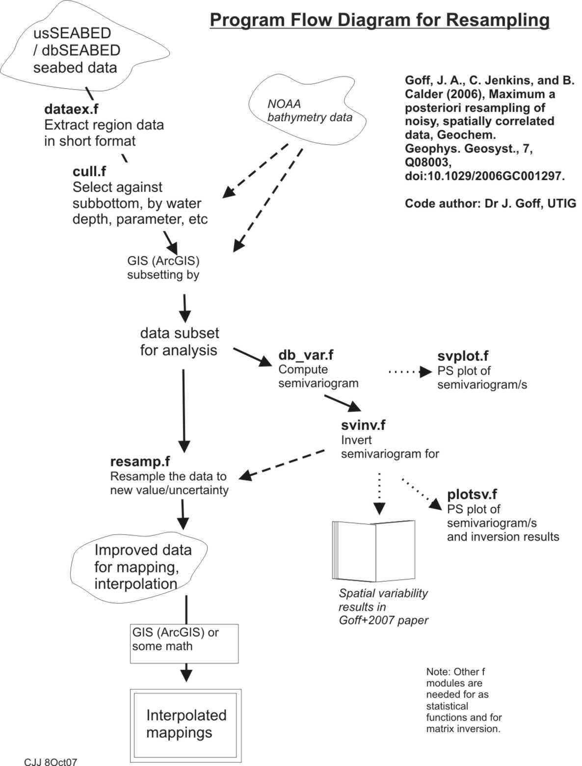
The software for resampling is available from HERE.
View the processing flow graphic here.
Use
the readme file there to arrange the input
data and software.
Check some example data, processed files and
a GMT plotting script.
Questions may be sent to the author of the code, John Goff at
UTIG.
References
Goff, J.A., Jenkins, C.J. & Calder, B. 2006. Maximum
likelihood resampling of noisy, spatially correlated data. Geochemistry,
Geophysics, Geosystems, 7(8), Q08003,[doi:10.1029/2006GC001297, ISSN:
1525-2027].
|
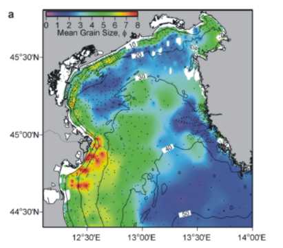
1. Resampled grid interpolation of the Northern Adriatic sediment
types.
This is output from the programs.
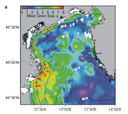
2. Ordinary kriging interpolation of the Northern Adriatic sediment
types.
This is a product of usual interpolations.
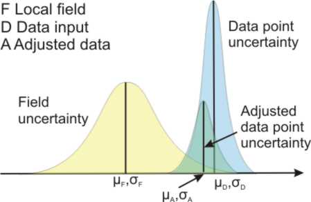
3. The adjusted mean and uncertainty for a data point is marked to the
overlap of the PDF's of the local field and input data values.
|
Phi grainsize units are logarithmic, -log2(grain
size in mm).
|