 |
Postglacial
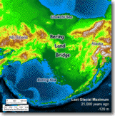
Flooding of the Bering Land Bridge: <-- The reduced-resolution animation at left shows sea level rising across the land bridge between Siberia (left) and Alaska (right). Full-resolution QuickTime movies are available below for analysis, education, and outreach. |
During the Last Glacial Maximum, about 21,000 years ago, global sea level was approximately 120 m (400 ft) lower than today. The Bering Land Bridge existed as a vast tundra plain connecting Asia and North America. As the world's glaciers and ice sheets melted over the following millenia, rising sea level flooded the land bridge — blocking migration routes for animals and humans.
The land bridge animation is based on the best available digital information, and reveals large-scale patterns of shifting coastlines and environments as the land bridge evolved. Bathymetry and elevation are color-coded in 1000 calendar-year time steps.
VIEW THE ANIMATION
The following QuickTime .mov files require QuickTime Player for Windows or Macintosh (as a standalone application or browser plug-in). Click on the links to view. Right-click or option-click to download for later use.
|
Large Window (624x630) |
Feel free to download the animations for use in websites or presentations. Please cite: Manley, W.F., 2002, Postglacial Flooding of the Bering Land Bridge: A Geospatial Animation: INSTAAR, University of Colorado, v1, http://instaar.colorado.edu/QGISL/bering_land_bridge.
OVERVIEW
Learn more about the land bridge, ongoing research, how the animation was created, and related uncertainties.
See Also: "Investigating an Arctic Gateway", a recent Geotimes article on the land bridge.
GIS DATA ONLINE
The Digital Elevation Model (DEM), including bathymetry, is available as a floating-point grid for use in Geographic Information Systems (GIS). Download blb1_dem.zip (3.3 MB), a compressed folder containing: .flt, .hdr, and .prj files; a thumbnail .gif file; and metadata files.
RELATED LINKS
- Marine Climate and Relative Sea Level across Central Beringia, an NSF-sponsored research project
- NPS Geology Field Notes for the Bering Land Bridge National Preserve
- Bering Land Bridge National Preserve Virtual Visitor Center
- Paleoenvironmental Atlas of Beringia
- Alaska PaleoGlacier Atlas
- INSTAAR Quaternary GIS Laboratory
- ETOPO2 Dataset
- USGS Bathymetry Coverages for the Bering and Chukchi Seas
- UNEP GRID-Arendal Arctic Environmental Atlas
ACKNOWLEDGEMENTS
The Bering Land Bridge animation is made possible through funding from the National Science Foundation's program for Arctic Natural Sciences (NSF Award OPP-9977972). Thanks go also to Julie Brigham-Grette (Univ. of Massachusetts), Scott Elias (Royal Halloway - Univ. of London), and Darrell Kaufman (N. Arizona Univ.) for constructive comments.