Paleoglaciology
of Alaska:
Climate Parameters during the Last Glacial Maximum from GIS Determination of Equilibrium Line Altitudes
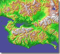
The slideshow at left depicts some of the processing steps and results for Seward Peninsula, NW Alaska.
OVERVIEW
Recent advances in Geographic Information Systems (GIS) enable us to estimate past climate parameters from glacial-geologic records. This project combines field research and cosmogenic-surface-exposure dating with GIS analysis of Alaskan glaciers that existed during the Last Glacial Maximum (LGM).
- Former glacier extents, coupled with high-resolution Digital Elevation Models (DEM's), permit us to quantify past Equilibrium Line Altitudes (paleo-ELA's).
- For each glacier, this parameter records a balance between winter precipitation and summer temperature.
- Dense spatial arrays of hundreds of paleoELA's within 8 broad mountainous regions clarify: microclimatic vs. regional climatic controls on glacier growth; synoptic views of atmospheric moisture circulation; and spatially varying LGM aridity for comparison with numerical climate simulations.
In sum, this project helps document magnitudes, processes, and sensitivity of natural climate dynamics operating on Alaskan glacier systems about 20,000 years ago.
PARTICIPANTS
|
Principal Investigators:
|
Graduate Students:
|
Research Assistants:
|


Collaborators include Marc Caffee (PRIME Lab, Purdue University), Mark Dyurgerov (INSTAAR), Christopher Daly (Oregon State Univ.), and K.Lea Ginnodo (USGS Rocky Mountain Mapping Center).
FIELD RESEARCH
For selected, little-studied areas in Alaska, we are conducting glacial-geologic field research to better constrain the limits of valley glaciers during the LGM. Over two summers we have visited seven areas: the northern Ahklun Mountains, Chuilnuk & Kiokluk Mountains, westernmost Alaska Range, Kokrines Hills, Zane Hills, Mt. Prindle area, and central Yukon-Tanana Upland. In each area we mapped glacial limits, studied relative-weathering characteristics of deposits, and sampled moraine boulders for cosmogenic, surface-exposure dating. The samples, observations, and associated air-photo interpretation form a foundation for the paleoELA research.
COSMOGENIC SURFACE-EXPOSURE DATING
To establish age control for the paleoELA analysis, we have prepared and analyzed 30 boulder samples for surface-exposure dating (with measurement of cosmogenic 10Be and, in some cases, 26Al). An additional 16 samples are currently being processed. This approach clarifies the timing of past climate forcing for glacial records that are otherwise undatable. Preliminary findings include: a prominent readvance about 11,000 cal yr BP in the Ahklun Mountains; major Early Wisconsin advance -- but a restricted Late Wisconsin pulse -- in the westernmost Alaska Range; and younger-than-expected pre-LGM limits in the Yukon-Tanana Upland.
SPATIAL ANALYSIS
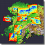 The
GIS effort is well underway for the eight project areas across Alaska.
DEM's were assembled at 60 m grid-cell resolution for >610,000 square
kilometers. Glacier extents for at least two glacial maxima were digitized
into the GIS for Seward Peninsula, the Ahklun Mountains, and part of the
Yukon-Tanana Upland. More than 80 GIS scripts (for discrete processing
steps) have been written, tested, and applied. Results to date include:
strong microclimatic control for the last two glacial events on Seward
Peninsula; and northeastward moisture transport with drier-than-present
LGM winters for the Ahklun Mountains. As part of a collaborative effort,
we are also compiling GIS layers of Alaska-wide glacier extents for a
global INQUA digital atlas.
The
GIS effort is well underway for the eight project areas across Alaska.
DEM's were assembled at 60 m grid-cell resolution for >610,000 square
kilometers. Glacier extents for at least two glacial maxima were digitized
into the GIS for Seward Peninsula, the Ahklun Mountains, and part of the
Yukon-Tanana Upland. More than 80 GIS scripts (for discrete processing
steps) have been written, tested, and applied. Results to date include:
strong microclimatic control for the last two glacial events on Seward
Peninsula; and northeastward moisture transport with drier-than-present
LGM winters for the Ahklun Mountains. As part of a collaborative effort,
we are also compiling GIS layers of Alaska-wide glacier extents for a
global INQUA digital atlas.
GIS DATA ONLINE
Download high-resolution DEM's and shaded relief images for this project's study areas.
RELATED LINKS
ACKNOWLEDGEMENTS
This research is made possible through funding from the National Science Foundation's program for Arctic Natural Sciences (OPP-9977972), with additional support from the Arctic Research Support and Logistics program. Access to the glacial records was kindly provided by numerous native corporations, the State of Alaska, the Bureau of Land Management, and the National Park Service.