The author(s) will give a talk
Vegetation around six lakes along a climate gradient in Baffin Island
1 Institute of Arctic Biology, University of Alaska Fairbanks
2 University of Münster, Germany
3 Washington State University Tri-Cities
4 INSTAAR, University of Colorado Boulder
5 INSTAAR, University of Colorado Boulder
The eastern Canadian Arctic encompasses the entire Arctic bioclimate gradient, from treeline to ice caps. We sampled and mapped the vegetation around a series of lakes along this gradient. Vegetation plots were sampled around the lakes, and cover values were recorded by species for lichens, bryophytes and vascular plants, and plant communities were identified for mapping. The maps show a 1-km² area around the lakes, using a consistent legend, so that vegetation units can be compared between lakes. The lakes include one near Pond Inlet, Baffin Island, Nunavut (next to an ice cap, 72.4 °N), one near Clyde River, two in the Merchant’s Bay area, one near Iqaluit, and one near Kuujjuaq, Nunavik, Quebec (at treeline 58.1°N) (Fig. 1).
The vegetation types ranged from rocky barrens with lichens to open spruce forest with low shrub and moss understory. The northernmost lake, AFR, has only recently become ice-free in the summer time. Summer warmth index, the sum of monthly average temperatures above 0 °C is only 0.6 °C (Fig. 2), with July the only month averaging above 0.0 °C. This is in the coldest bioclimate subzone in the Arctic, Bioclimate Subzone A (CAVM Team, 2003). One of the findings of this study was the importance of aquatic mosses in these arctic areas - at AFR they far outweigh the biomass of the terrestrial vegetation.
The next two lakes, BRO and CF8, had SWIs between 10 and 15 °C, Bioclimate Subzone C. BRO is in a mostly barren, steep landscape, with some prostrate dwarf-shrubs. The landscape around CF8 also had large barren areas, but also had patches of moist graminoid, cryptogam tundra, dominated by Luzula spp. (rushes) and liverworts.
The warmer arctic lakes, BIR and QPT, had SWI values around 25 °C, putting them in Bioclimate Subzone E. These temperatures are warm enough to support birch shrubs > 40 cm in height. Most of the landscape was vegetated, with a mix of moist erect dwarf-shrub tundra on rocky substrates, and moist graminoid, dwarf-shrub tundra on finer substrates.
The lake south of treeline (in the Boreal bioclimate zone, not Arctic), 3LN, had an SWI of 36.2 °C and a mean July temperature of 11.9 °C. Both of these values are warmer than the expected arctic maxima (35 °C SWI and 10 °C MJT (CAVM Team, 2003)), confirming these southern bioclimate limits for the Arctic. The landscape around this lake included glaciated ridges with vegetation between the bedrock outcrops, open spruce-larch forest with low shrubs and moss understory, and even some peat palsas.
These maps will be used to compare current vegetation with evidence of past vegetation found in cores from the lakes, which include times both warmer and colder than present (Crump et al. 2021). The differences along the climate gradient will also be helpful in predicting the response of vegetation to current climate warming. Other mapping that is being done as part of this project includes bathymetry mapping and lake catchment mapping (Fig. 3).
CAVM Team, 2003, Circumpolar Arctic Vegetation Map, scale 1:7 500 000, Conservation of Arctic Flora and Fauna (CAFF) Map No. 1, U.S. Fish and Wildlife Service, Anchorage, Alaska.
Crump, S. E., B. Fréchette, M. Power, S. Cutler, G. de Wet, M. K. Raynolds, J. Raberg, J. P. Briner, E. K. Thomas, J. Sepúlveda, B. Shapiro, M. Bunce, and G. H. Miller, 2021, Ancient plant DNA reveals High Arctic greening during the Last Interglacial: Proceedings of the National Academy of Sciences, v. 118, n. 13.
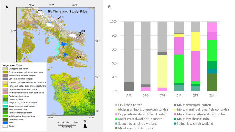
Fig 1.
A. Location of six lakes that are part of a study of lake cores and vegetation along a climate gradient in the eastern Canadian Arctic. Five of the lakes are on Baffin Island, Nunavut, and one is near Kuujjuaq, Nunavik, in northern Quebec. B. Proportions of different terrestrial vegetation types in 1-km² maps around the lakes.
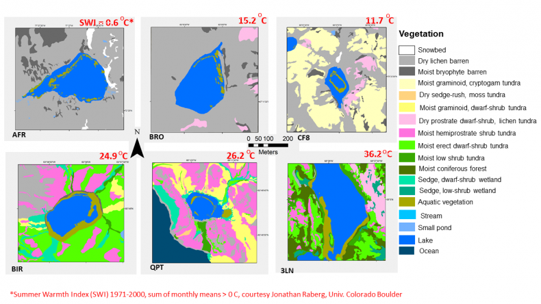
Fig 2.
Maps of 1-km² around six lakes along a climate gradient in the eastern Canadian Arctic. Note the mapping of aquatic vegetation, dominated by aquatic mosses in the five arctic lakes. Aquatic vegetation at QPT and especially at the boreal lake, 3LN, included several vascular species.
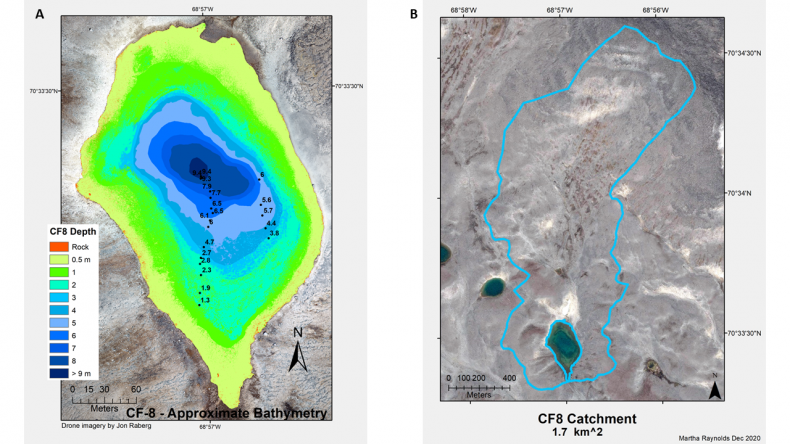
Fig 3.
Example of bathymetry mapping and lake catchment mapping for lake CF8, near Clyde River, Nunavut.