|
dbSEABED creates
unified, detailed
mappings
of the materials that make the seafloor by efficiently
integrating thousands of individual datasets. The goal is to bring
decades
of
seabed information - and today's latest information - from marine geology,
biology, engineering
and
surveys
into one seabed mapping that can fulfil the community needs for
ocean-bottom
information on many spatial scales. The system deals with
seabed
texture,
composition, acoustic properties, colour, geology and biology.
Many software tools can work on
the rich
integrated data: Geographic Information Systems
(GIS), Relational Databases
(RDB), modeling, visualisation, and stratigraphic .
Huge
data
entry efficiencies come from programs that prepare the data
for use
in standard databases. As
evidence
of its efficiency, the US, Australian and global coverages together
hold integrated data for over 3,000 datasets and 5 million
described seafloor sites. The system is
vendor-independent and code is shared, so the system will be a legacy
well
into the future. The scope of the project
is large: global extent, shorelines to abyss, across all national
jurisdictions, public and donated data, numerical and text data
types.
Seafloor Substrates
mapping, Google Earth View

This
very coarse resolution view shows the provincial variations of exposed
rock and seabed textures for the states Texas, Louisiana, Mississippi,
Alabama and Florida. It is one of the public data offerings
from
dbSEABED. More detailed, extensive data is used for the research.
To look further, visit HERE
or put this URL
"http://instaar.colorado.edu/~jenkinsc/dbseabed/kml/dbS_global.kml"
into your
GoogleEarth 'Add/Network Link' tool as "dbSEABED" and
double-click.
The Outputs Available to Users
- Pointwise data
at the level of individual samples and observations, integrated and
harmonized from the inputs of the third-party datasets. Formatted as
text tables, CSV, Shapefiles, Pandas, etc.
- Rasterized (cellwise) data with statistics of the averages and variances. Formatted as ESRI grids, GeoTiffs, NetCDF, etc.
- Interpolated mappings rendered as griddings, or vectorized to Shapefiles. Formatted as ESRI grids, GeoTiffs, NetCDF, etc.
- Specialized visualizations of coring results and subbottom distributions. Formatted as VRML, database, etc.
- The
parameters supplied are sediment textures (gravel, sand, mud, grainsize
average and sorting, Folk codes); composition (carbonate, organic
carbon); grain types; mesoscopic features; seabed colour,
roughness dimensions.
Public datasets include the KML Global Mapping and miscellaneous data offerings through partners such as NOAA. Otherwise contact the Systems House (INSTAAR) for data.
A brief Data Agreement
is usually required for data supply, with a project abstract attached.
Data is supplied on a per-project basis to prevent circulation of
out-of-date versions and the data not used in a fit-for-purpose way on
projects. A service fee may be charged for development, supply and
technical support.
dbSEABED provides data pro bono to selected student research thesis projects, particularly those leading to a degree.
The project always appreciates new data to add to the system and information from users on their applications for the data.
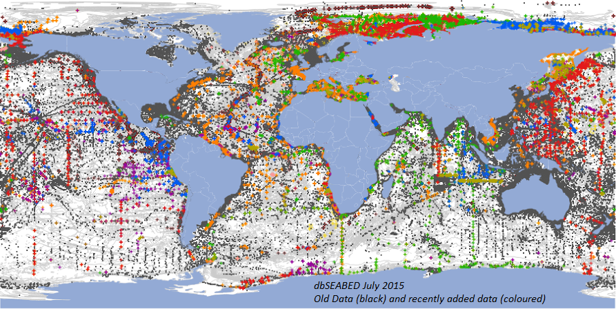
Global Coverage in the Compositions of Seabed Materials
The
system at last tally had over 5 million described samples at 3 million
sites worldwide. This has been possible to assemble through
the
generosity and efforts of collaborators, and also through the use of
software for data entry, integration and quality checking.
|
Advancing with Substrates' Mapping for the Arctic Ocean
 (Click to enlarge) (Click to enlarge)
First
whole-of Arctic surficial sediment coverages now available at various
resolutions (August 2020). This particular coverage is of the sand
fraction, interpolated on an x,y and z (water depth) inverse-distance
metric. (Click to Enlarge.) Points mark the presently available data sites.
dbSEABED is now able to produce mappings for any region in any chosen map projection, such as this one, which is in IBCAO
Polar Stereographic at resolution 10km cellsize. |
Notes
The
scale of operation is local, national and global: shorelines,
bays,
seaways, national EEZ's, ocean basins, and worldwide. The
database deals with coastal, estuarine, inshore,
continental shelf, continental slope and very deep sea environments.
Point-data based, so spatial
resolution improves as more datasets
are
added.
Gridded and vector mappings of the seafloor materials are computed from
the point-data coverages. Accuracies are the same as for the original
survey
data; system precision is 1m; datum is WGS84.
Seabed Coring Datasets - Databased and Visualized
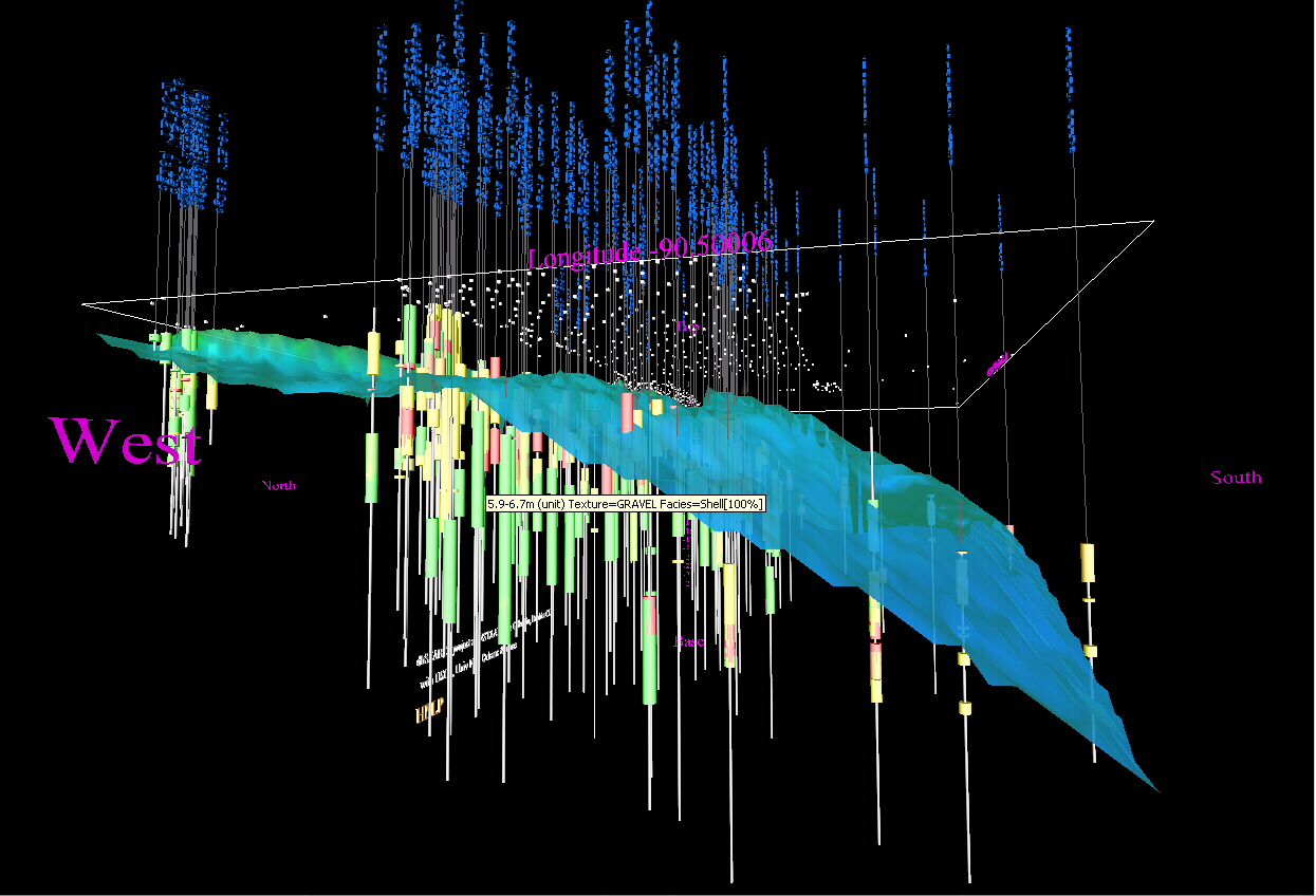
(Click to enlarge)
As
shown in this example from Ship Shoal, Louisiana, dbSEABED has the
capability to integrate seabed-penetrating core information, lodge it
in database (of client choosing) and then also to create a 3D
fly-through interface for querying the data. Statistics on the
subbottom composition and layering are also computed. Surface sediment samples are also a component. Built for the
CoreWall project and German North Sea geoacoustics.
dbSEABED is operated
by
a number of cooperating institutions, who import, integrate,
process
and display regional datasets under a common format and software setup.
They share data, code and innovations. Some organizations use dbSEABED
on their secure premises where they add their own specialized datasets
to
the
group data holdings.
Quality
assurance
is achieved by checks on data at data entry (including always, operator scrutiny), by error-trapping in
the data-processing software, and by working the data intensively in
various
collaborative research programs. dbSEABED was devised to be robust in
an
inexact and incomplete information environment - marine geosciences. An
uncertainty budget is calculated with map outputs.
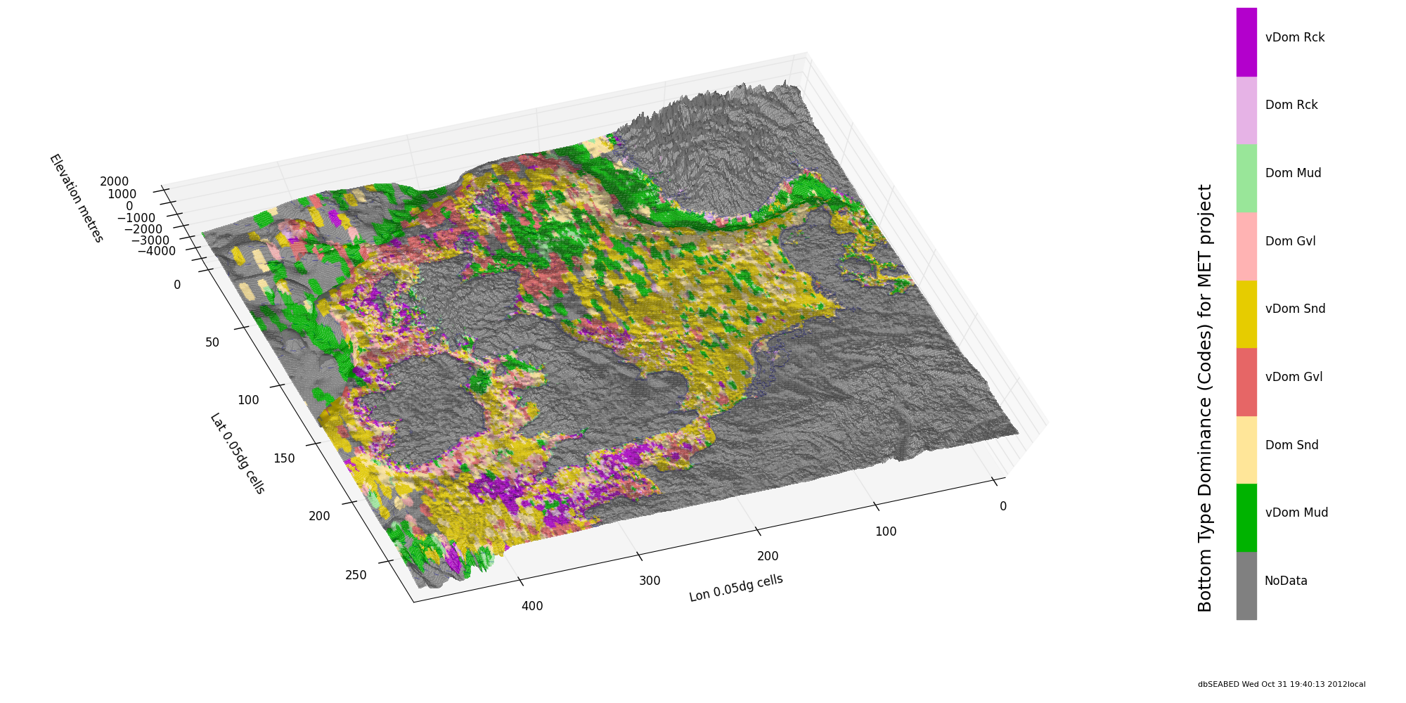
The most common applications are real input data for numerical models, ecological benthic habitat mappings, lithological compositions of sediments, sediment template to guide biogeochemical studies and budgets.
dbSEABED
display
of dominant seafloor type for the NW European Shelf (North Sea)
region. This regional
coverage was developed to help with a numerical modeling of tides. It represents over 60,000 sites all from public data sources. The
detailed gridded data is available on request.
|
