auSEABED
Seabed Stability under
Storms
- Benthic 'Creature
Weather'
in Bass Strait, Australia
Animated maps show the modelled
benthic disturbance
under a week-long severe winter storm
|
|
Abstract
A GIS macro has been created to
predict sediment mobility over the Bass Strait seafloor on a gridded,
time-progressive
basis. The results is a series of movie-maps (digital animations)
which model environmental conditions at the seafloor.
Wave data was provided by
WNISE,
where wave heights had been modelled on an hourly basis for one week
over
an 11km grid covering Bass Strait. That modelling was based on wind
data
from the National Center for Environmental Protection (USA) with
validation
of results from a monitoring station used by the Bass Strait oil/gas
industry.
Other inputs included point sediment-attributes from the auSEABED
database
at Sydney University, 1 nm gridded bathymetry from AGSO and
oceanographic
inputs from the RAN Australian Oceanographic Data Centre (AODC). The
data
sets were re-gridded to the wave grid dimensions and sediment types
were
transferred to motion thresholds using the Shields Criterion with
appropriate
viscosities and grain densities.
Bottom orbital velocities (in
the
absence of currents) were computed using Airy Linear Wave Theory and
Stokes
Second Order Wave Theory (for shallow waters). Three types of GIF
animation were then constructed drawing on both methods:
wave heights, directly from
the WNISE
data
bottom orbital velocity
motion excess over sediment
motion
threshold.
The animations are in hourly
steps
though the week of 20-26th May 1998 which was a particularly stormy
week.
Significant wave heights attain 8m. Note that these waxing-waning storm
conditions are a very different scenario from earlier modellings of
seabed
wave disturbance which have used invariant swell wave statistics.
Maximum sediment disturbance
occurred
in shallow water areas of Bass Strait, primarily in the lee-sides of
islands
and elsewhere in the more sheltered waters. Elsewhere, sediment
textures
and consolidations are apparently adjusted to peak storm conditions in
the strait or the water depths were beyond the influence of wave
induced
motions.
The unusually high degrees of
disturbance
in the most sheltered waters at first appeared to be a strange result
but
was checked and verified. The explanation appears to be that in those
areas,
the sediments deposit during late waning wave conditions and also are
not
transported away at peak roughness. Having been deposited under late
and
weak wave conditions they are then very prone to re-mobilization from
early
in the next storm wave build-up, especially if the deposits create
shallow
drifts. There are certain similarities to beach sediment behaviour.
The project's successful
outcome
will be used to refine the modelling, particularly in treatment of
shallow
water wave behaviour, erosion thresholds, seabed roughness and
wave-current
interactions.
Data Sources
|
|
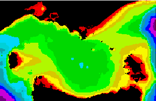
<< Water Depths
Compiled and gridded by
Cameron
Buchanan of
AGSO
(10m intervals 0..100m,
then at 200,500,1000,2000,4000m) |
|
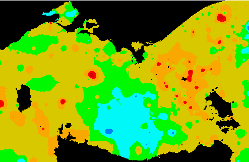
Sediment Texture >>
Compiled and gridded by
Chris
Jenkins of OSI
(2 phi intervals
from dk red gravel -6..-4 phi
to dk blue mud 6..8phi)
|
|
 |
|
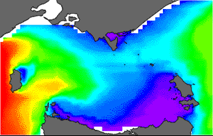 |
<< Wave Heights (Hs)
Modelled by Alfons
Lemm of WNI
1 week starting 20 May 1998,
1 hourly frames, 11km gridding
|
Also available were weekly
data on wave periods and
directions as modelled by
Alfons Lemm of WNI
|
|
Output Movie Maps
|
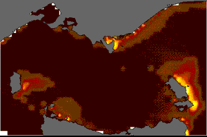
<< Bottom Orbital Velocity
(Umax)
- the speed of water flows
across bottom
|
Motion Excess (Uexcess) >>
- excess in bottom water velocity
above the threshold
of sediment movement
(an index of disturbance)
|
|
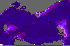 |
Computed and assembled by Tanya Schindler
1 week starting 20 May 1998, 1 hourly frames, 11km
gridding
(The movies not quite synchronized; the gridding
scale
may leave very inshore results open to revision)
Return to auSEABED
home
Return to dbSEABED
home
Back
to top
(Web site
updated:
11 Oct 2002, CJJ)
Email: Chris
Jenkins & Tanya Schindler
Project done
at
School of Geosciences,
The
University of Sydney