ANSCIA
Barrow
Ground Control Point
Database
v1
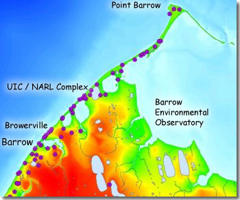
The purple
circles at left depict the 63 GCP's near Barrow.
Overview:
This series of web pages presents site information for 63 Ground Control Points (GCP's) measured near Barrow, Alaska, during the summer of 2001 using Differential GPS. The GCP's were measured on the corners of buildings, ends of snowfences, base of telephone poles, and other features visible on small- to large-scale imagery. They are concentrated generally within 2 km of the Chukchi coast (coinciding with extent of the year 2000 air photos). The GCP's will help researchers and other scientists working in the area to establish precise geographic or UTM coordinates for field sites, and to assist with georectification of aerial photography and satellite imagery.
The GCP's were measured as part of an ongoing research project, Alaska North Slope Climate Impact Assessment (ANSCIA), which is funded by the National Science Foundation's program on Human Dimensions of the Arctic System. This database is being made publicly available as part of our objectives for data sharing and outreach to both the scientific community and the public at large.
GCP'S:
Follow the links below to view information for each GCP, including:
- a photograph of each site from the ground
- vertical close-up and overview images, cropped and edited from areal photography (North is upper left)
- latitude, longitude, UTM coordinates, elevation, horizontal precision, vertical precision, and other parameters
Please see the metadata page for details about projection, datum, collection procedures, processing steps, precision, contact and citation information, etc. The metadata should be reviewed carefully before using any of the information provided here. Note that the datum for the latitude/longitude and UTM (zone 4) coordinates is WGS84.
ANSCIA Barrow GCP Database v1
C000 C001 C002 C003 C005 C006 C007 C008 C009 C010 C011 C012 C013 C014 C015 C016 C017 C018 C019 C020 C021 C022 C023 C024 C025 C026 C027 C028 C029 C030 C031 C032 C034 C035 C036 C037 C038 C039 C040 C041 C042 C043 C044 C045 C046 C047 C048 C049 C050 C051 C052 C053 C054 C055 C058 C059 C060 C061 C062 C063 C064 C065 C066
Related Links:
- Back to the ANSCIA Data Sets page.
- Trimble site for explanation of Differential GPS.
- National Geodetic Survey site for explanation of datums.
- An excel worksheet containing the GCP information.
- INSTAAR QGIS Laboratory
Acknowledgements:
This database was made possible by support from NSF's Arctic System Science (ARCSS) Program. We also thank the Arctic Research Support and Logistics Program, which enabled participation of GPS technical experts from the UNAVCO Facility. Presentation of the close-up and overview images, derived from proprietary aerial photography, was made possible through a licence agreement with AeroMap, U.S.
Copyright © 2001, Univ. of Colorado. Links on these pages to non-university sites do not represent endorsement by the University of Colorado at Boulder or its affiliates.