|
ANSCIA
Barrow GCP Database v1
Intro C000
C001 C002
C003 C005
C006 C007
C008 C009
C010 C011
C012 C013
C014 C015
C016 C017
C018 C019
C020 C021
C022 C023
C024 C025
C026 C027
C028 C029
C030 C031
C032 C034
C035 C036
C037 C038
C039 C040
C041 C042
C043 C044
C045 C046
C047 C048
C049 C050
C051 C052
C053 C054
C055 C058
C059 C060
C061 C062
C063 C064
C065 C066
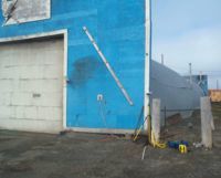
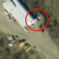
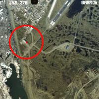
| GCP_ID: |
C028 |
| Feature Type: |
building |
| Description: |
SE corner of old blue and white building, "Barrow Utilities and Electric Co-op", near beach, W of western end of Barrow runway |
| Latitude (DD): |
71.28645245 |
| Longitude (DD): |
-156.80334656 |
| UTM Northing (z4, m): |
7,910,773.32 |
| UTM Easting (z4, m): |
578,644.23 |
| Elevation (m): |
11.58 |
| Horiz. Precision (m): |
0.02 |
| Vert. Precision (m): |
0.04 |
| Acquisition Date: |
8/17/2001 |
| Measured by: |
Manley and Dyurgerov |
| Air Photos: |
2000 4-3, 4-4 |
| Point Resolution: |
4 cm |
| Comments: |
Using a tripod, at SE corner of building; the oldest part of the building, a quonset-hut type half cylinder, is visible on the 1979 photos, and has a flat rectangular vertical faade facing south (in the 2000 photos the face of the faade is visible, as well as the cylindrical roof); since 1979, additions have been made to the W side of the building. |
|