The author(s) will give a talk
Evidence for a more extensive Greenland Ice Sheet in southwestern Greenland during the Last Glacial Maximum
2 Presenting Author
1 University at Buffalo
2 University at Buffalo
3 University at Buffalo
4 University at Buffalo
5 University at Buffalo
6 Lamont-Doherty Earth Observatory
The maximum extent and elevation of the Greenland Ice Sheet (GrIS) in southwestern Greenland during the Last Glacial Maximum (LGM, 26-19.5 ka) is poorly constrained. Yet the size of the GrIS during the LGM helps inform estimates of past ice sheet sensitivity to climate change and provides benchmarks for ice sheet modeling. Reconstructions of LGM ice extents vary between an inner-continental-shelf minimum, a mid-shelf position, and a maximum extent at the shelf break. We use three approaches to resolve LGM ice extent in the Sisimiut sector of southwestern Greenland. First, we explore the likelihood of minimum vs. maximum GrIS reconstructions using existing relative sea level data. We use an empirical relationship between marine limit elevation and distance to LGM terminus established from other Northern Hemisphere Pleistocene ice sheets as context for interpreting marine limit data in southwestern Greenland. Our analysis supports a maximum regional GrIS extent to the shelf break during the LGM. Second, we apply a simple 1D crustal rebound model to simulate relative sea level curves for contrasting ice sheet sizes and compare these simulated curves with existing relative sea level data (Figure 1). The only realistic ice sheet configuration resulting in relative sea level model-data fit suggests that the GrIS terminated at the shelf break during the LGM (Figure 2). Lastly, we constrain the LGM ice sheet thickness using cosmogenic 10Be, 26Al and 14C exposure dating from two summit areas, one at 381 m above sea level at the coast, and another at 798 m asl 32 km inland. Twenty-four cosmogenic radionuclide measurements, combined with results of our first two approaches, reveal that our targeted summits were likely ice-covered during the LGM and became deglaciated at ~11.6 ka. Inventories of in situ 14C in bedrock at one summit point to a small degree of inherited 14C and suggest that the GrIS advanced to its maximum late Pleistocene extent at 17.1 ± 2.5 ka. Our results point to a configuration where the southwestern part of the GrIS reached its maximum LGM extent at the continental shelf break. To celebrate John Andrews’ foundational work on glaciation and isostasy, this presentation will focus on the first two approaches highlighted above.
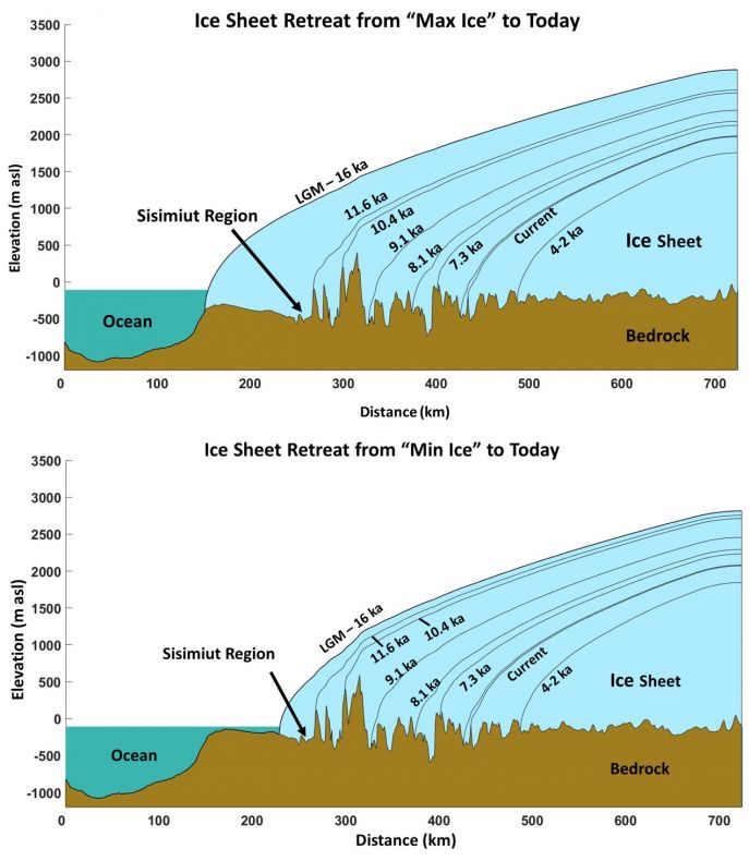
Fig 1.
Figure 1. Cross section of crustal rebound model showing "max ice" and "min ice" LGM position and retreat history.
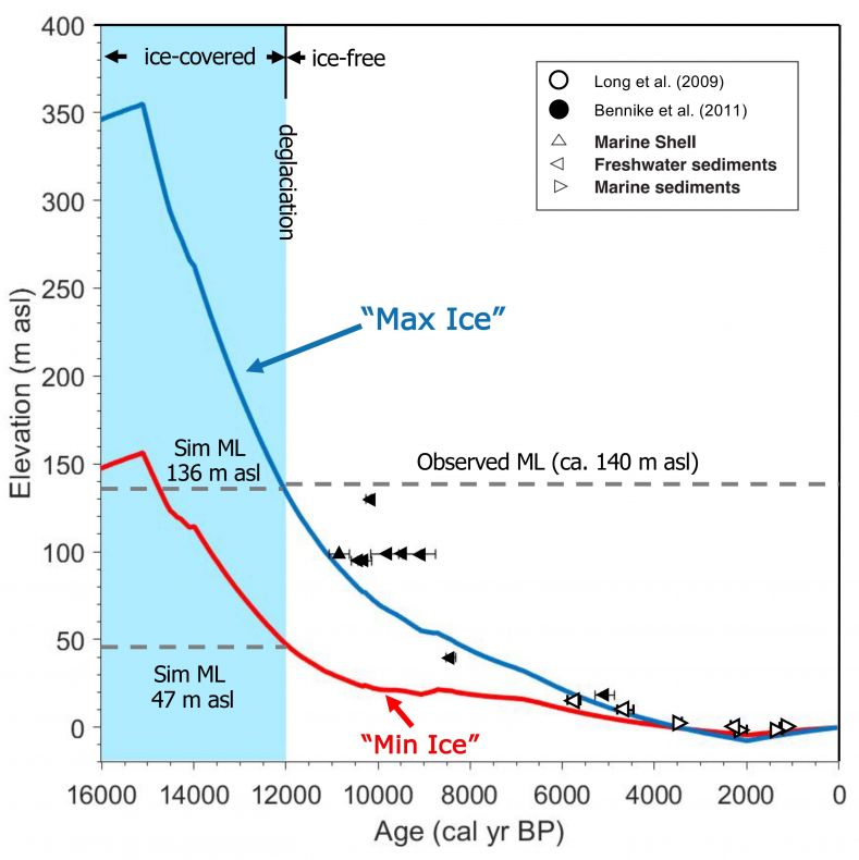
Fig 2.
Figure 2. Simulated relative sea level curves for Sisimiut, Greenland, for "max ice" and "min ice" simulations. Independent relative sea level constraints are also shown.