The author(s) will give a talk
Torrent or trickle?: Tracking glacial lake evolution and flood events using composite lake records
1 Woods Hole Oceanographic Institution
2 Woods Hole Oceanographic Institution
3 Woods Hole Oceanographic Institution
4 Woods Hole Oceanographic Institution
Glacial meltwater inputs have long been hypothesized to weaken Atlantic Meridional Overturning Circulation (AMOC) leading to Northern Hemisphere cooling, particularly during deglaciation from the last glacial period. While much work has been done to constrain the timing and magnitude of meltwater inputs during deglaciation as well as their potential impacts on AMOC, less is known regarding the effect of meltwater input event duration and/or frequency. For example, recent numerical modeling by our group that performed a large suite of simulations to examine a variety of potential drainage scenarios for Lake Iroquois (e.g., high flux short-duration, low discharge long-duration, multiple floods) showed that with existing constraints on the total volumes of meltwater, the drainage of this lake was unlikely (without significant additional climatic forcings) to have been the main driver of the Intra-Allerød Cold Period. However, the impact of Lake Iroquois flood duration and frequency, particularly in combination with contemporaneous meltwater inputs or other circulation mechanisms remains unknown. As a step toward filling this knowledge gap, here we report on new efforts to constrain the timing, duration, and frequency of glacial meltwater flood events originating from glacial Lake Iroquois, which entered the North Atlantic through the paleo-Hudson Valley sometime around ~13.2 ka.
Initial seismic surveys of modern lakes across Lake Iroquois paleo-shorelines in northwestern New York State indicate higher density, laminated sediments overlain by lower density, more homogenous sediments, separated by an abrupt transition (Fig. 1). Pilot cores from several lakes confirm this stratigraphy with higher density silt and clay sequences overlain by lower density gyttja. This stratigraphy supports glacial lake sedimentation when the modern lake was part of the larger Lake Iroquois, transitioning to lower density gyttja deposited after the modern lake was isolated by lake level lowering associated with Lake Iroquois drainage. This transition from glacial lake to non-glacial lake sedimentation is seen in pilot cores from additional lakes in a transect to the northwest, in each case marked by a sharp increase in organic content as well as changes in multiple geochemical proxies. In Lake Bonaparte (Fig. 1) radiocarbon dating of preserved macrofossils provides age control for the younger, non-glacial lake sequence. However, the lack of macrofossils in the older glacial lake sequence and scatter in bulk sediment 14C ages prevents precise 14C constraint of the transition from glacial lake to non-glacial lake sedimentation. However, varves in the glacial lake sequence were correlated to established varve chronologies in New England providing age control below the glacial lake to non-glacial lake transition. A composite age model of 14C and varve chronology constrains the transition to 13.2 ± 0.4 ka, within the range of existing age control on the initial flood event from Lake Iroquois.
Short pilot cores from additional lakes contain limited glacial lake sequences with no identifiable varves. Upon retrieval of cores capturing longer glacial lake sequences from all lakes, we aim to cross-correlate individual varve sequences (present in the seismic data) to compile a composite chronology across the Lake Iroquois paleoshoreline features, capturing the evolution of Lake Iroquois from its largest phase up to the marine incursion in the St. Lawrence Valley that followed the demise of the Lake (Fig. 1). Correlation of the varve sequences between lakes and the annual nature of varve deposition provides the best opportunity to generate a high-resolution chronology of lake-level lowerings associated with Lake Iroquois meltwater flood events. This approach will provide new constraints on the absolute timing as well as the frequency and range of possible durations of these flood events.
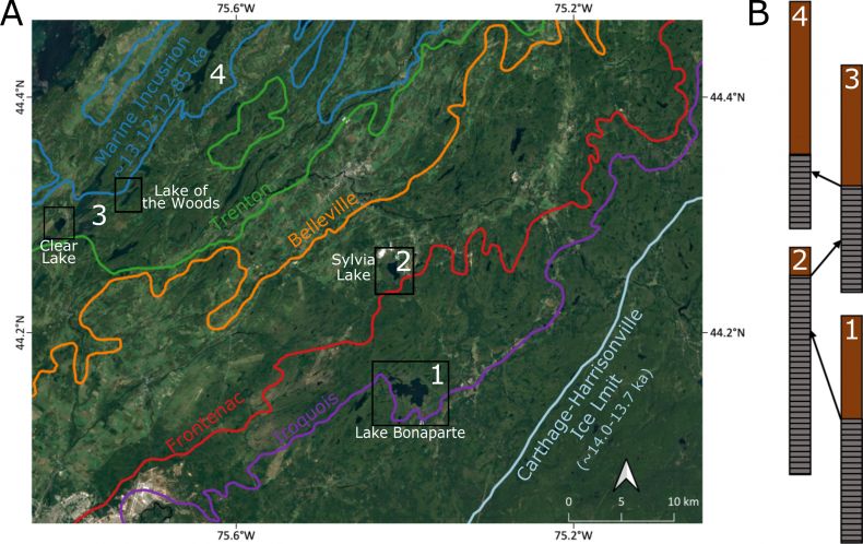
Fig 1.
Map of target lakes in northwestern New York state. A) shows the pre-lake Iroquois Laurentide Ice Sheet margin (light blue line) as well as the limit of the marine incursion (dark blue line) following the final drainage of Lake Iroquois. Other colored lines denote the location of identified paleoshoreline features. Pilot cores already retrieved from four lakes (black boxes) each contain the transition from glacial lake to non-glacial lake sedimentation. B) A schematic illustrating the proposed cross-correlation between target lakes (white numbers) to generate a composite varve chronology of the evolution of Lake Iroquois and its drainage events.