SYLLABUS
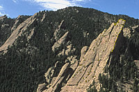
Photo of Boulder Flatirons taken from small airplane to help build a photogrammetric 3D model. Photo: Tad Pfeffer.
Three day tutorial
A custom-designed class taught by a multi-disciplinary expert.
Syllabus: Print Version (PDF)
1. Overview
- Utility of photogrammetric analysis
- Example applications
- Special advantages, limitations
2. Essential Theory:
- Principles of single image formation
- Principles of stereometric image formation
- Camera characteristics
- Extraction of coordinate data
- Model accuracy: Range to object, image resolution, camera position
3. Single Camera Example:
- Exterior orientation from ground control
- Topographic assumptions
- Extraction of image space coordinates
- Unknown camera
4. Practice: Tabletop Model
- Initial model setup: import images, define camera
- Fiducial marks (for film images)
- Point selection and reference
- Initial 3D model formation
- Errors, refinement of point selection
- Additional points, more errors and model refinements
- Lines and surfaces
- Surface rendering
- Output: Coordinate files, CAD formats, orthorectified images.
Projects
4. Geotechnical Example 1: Rock outcrop (Boulder Canyon)
- Extraction of rock joint surface orientations
- Joint intersection calculations
5. Glaciological Example: Glacier Mapping (Arapaho Glacier)
- Typical issues in glaciological problems
- Ground control
- Optimizing resolution and range
- Extraction of topographic profiles
6. Architectural Example 1: Building Facade on CU campus
- Typical issues in architecture problems
- Curves, planar constraints
- Extraction of 3D measurement data from images
- Importation to CAD
7. Architectural Example 2: Historic structure
- Typical issues in historic documentation
- Extraction of orthorectified facades
- Using photogrammetry with HABS/HAER Documentation
8. Field Example: Photographing a structure
- Project design
- Optimizing resolution and range
- Ground control
- Defining objectives and choosing camera positions